

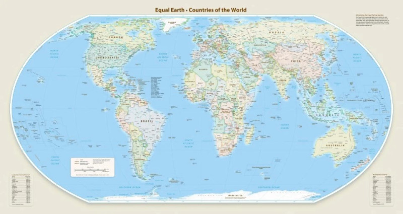
THE United Nations General Assembly has voted overwhelmingly to endorse a new world map that gives Africa a more proportionate representation while reducing the apparent size of Europe and North America, drawing sharp criticism from the United States.
AFP, on Saturday cited that the resolution, backed by 164 countries, calls for the adoption of the “Equal Earth” cartographic projection to improve the accuracy of how the world’s land masses are represented.
The United States voted against the resolution, while six countries abstained.
The resolution encourages UN member states to use the Equal Earth projection as an alternative to the traditional Mercator projection, which was developed by Flemish cartographer Gerardus Mercator in 1569 primarily for maritime navigation.
Togo, which sponsored the resolution, said maps played an important role in shaping how people perceived the world.
“Therefore, maps are never neutral; when they portray a distorted image of our planet, they risk perpetuating inaccurate representations inherited from one generation to the next,” Togo Foreign Minister Robert Dussey said.
The United States, however, criticised the initiative, arguing that the UN should focus on more pressing global challenges.
“Instead of focusing on real problems, this body is instead debating a 16th-century map project and its role in promoting compensation and cognitive justice,” US representative Yaryna Ferencevych said before the vote.
The Mercator projection accurately preserves the shapes and angles of land masses in many areas, but significantly distorts their relative sizes because of the difficulty of representing the three-dimensional globe on a two-dimensional surface.
The projection enlarges areas towards the poles while compressing regions around the Equator, making Europe and North America appear considerably larger while Africa and South America appear smaller than their actual relative areas.
The Equal Earth projection was developed by a group of cartographers and introduced in 2018. It provides a more proportionate representation of Africa, Latin America, South Asia and Oceania.
“Equal Earth preserves the relative surface areas of continents and, as much as possible, shows their shapes as they appear on the globe,” one of its cartographers, Bojan Savric, told AFP in 2025.
France, which co-sponsored the resolution, also announced on Friday that it would stop using the Mercator projection.
“On that map, the US, Russia and China receive disproportionate visual prominence compared with Africa, Latin America or Southeast Asia, while Greenland appears almost as large as Africa.
“Changing the map obviously does not change the world. However, correcting a distorted representation is already an act of truth,” French Foreign Minister Jean-Noel Barrot said.
The initiative comes as France seeks to improve relations with African countries, particularly former colonies where ties with Paris have become increasingly strained. - September 5, 2026








.jpg)