

SEREMBAN – Jelebu is said to be Negri Sembilan’s most fertile district and is especially known for its durian species. It also receives the least rainfall in the state.
Ironically, during the December 18 floods, Jelebu was one of the worst-hit areas.
That day, seven other states besides Negri Sembilan were also battered by floods that were described as the most severe in 50 years.
Eleven locations in Jelebu were struck by floods when it rained heavily and continuously for over five hours, starting at 6pm on December 18.
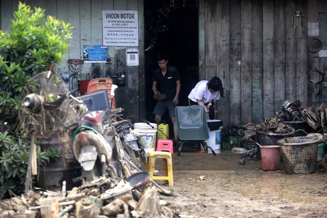
The severity of the flooding took the residents of affected villages such as Kg Chennah, Kg Poum and Kg Pah by surprise. They are still reeling from the shock of losing their possessions in the blink of an eye.
Some of their homes were entirely swept away by floodwaters, while some houses only have their roofs left.
Some dwellings are now tilted and cannot be inhabited, while others have been totally destroyed.
The floods also took a toll on the villagers’ crops and livestock.
Despite the destruction caused by the floods, the residents are, however, grateful that no lives were lost.
Worst-ever floods?
Jelebu is relatively sheltered from rain due to its location at the end of the Titiwangsa Range and its hilly terrain.
Despite Jelebu – Negri Sembilan’s second-largest district – being the state’s driest area, five of its weather stations recorded unusually heavy rainfall of over 100mm on December 18.
The previous day, the stations recorded rainfall of less than 60mm, which was considered normal.
On December 18, the station located in Ulu Klawang in Kuala Klawang recorded the highest rainfall of 199mm over a period of five hours – the equivalent of one month’s normal rainfall.
Other areas that recorded substantial rainfall that day were Kg Chennah (180.5 mm), Kg Chenor (162mm), Kg Juntai (142mm), the Malaysian Agricultural Research and Development Institute in Jelebu (136.5mm), and Kg Ladang Pertang (77mm).
According to Negri Sembilan Menteri Besar Datuk Seri Aminuddin Harun, the heavy and continuous rainfall on the evening of December 18 caused severe flash floods in several low-lying areas located near the Sg Triang basin.
He said that Sg Triang’s water level rose to 71.1m, which was 2.1m above the danger level.
“The dangerously high water level caused the road entering the nearby villages to be cut off. Most of the areas that were affected that day experienced rainfall distribution in excess of 100 ARI (average recurrence interval),” he said.
The inability of the water from rivers in the Sg Triang sub-basin – such as Sg Chennah, Sg Klawang, Sg Chempedak, Sg Gelami, Sg Kenaboi and Sg Jelebu – to enter Sg Triang led to the occurrence of the worst floods Jelebu has ever seen in 15 years, he added.
Floodwaters in some areas there rose to over 2m. Since the disaster was totally unexpected, none of the locals had made any preparation to face the floods.
Houses washed away
The day after the major flooding, many locations in Jelebu were practically inaccessible. Only one route – which went through Kuala Pilah and Kuala Klawang – could be used to get to Jelebu from Seremban as the usual road through Bukit Tangga was closed following a landslide.
Kg Kuala Pah resident Zaleha Shaharudin, 65, said all her household items were destroyed after the water level suddenly and quickly rose to 1m in height.
“The last time we experienced a huge flood was in 2005 but it was not as bad as the one we faced this time,” she said.
Another resident, Ibrahim Taib, 62, was worse off, as the house he had lived in with his wife and children for 35 years was washed away by the floodwaters.
“When the water level started to rise, my family and I shifted to a car wash that was located next to my house on higher ground. Then at about 2am (on December 19), my children woke me up to say that our house has been washed away. It happened so fast,” he said.
Meanwhile, about 50 farmers in Jelebu operating freshwater fish farms suffered losses amounting RM12 million due to the floods.
Also affected was Taman Eko Rimba Jeram Toi, a recreational forest with a four-storey waterfall that used to attract a lot of visitors.
Following the floods, the water turned murky. Not only that, a landslide there destroyed some of the amenities in the forest, including the gate at the entrance and food stalls.
The recent floods here are a clear sign that any area in this country is at risk of facing floods, even if it is known to receive relatively low rainfall. – Bernama, December 28, 2021