

.jpg)

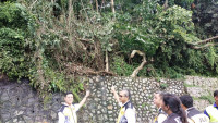
KUALA LUMPUR – The Selangor government is considering disclosing a risk-mapping study conducted by Universiti Teknologi Malaysia (UTM) on the condition of slopes and risk zones in Bukit Antarabangsa.
Selangor Housing, Urban Well-being, and Entrepreneur Development Committee chairman Rodziah Ismail said there have been several requests for the state to share findings by experts on the matter in the past two years.
It is learned that the study by a team of academicians was already presented to state agencies including Ampang Jaya Municipal Council (MPAJ) last year and since then, the documents have been placed under the Official Secrets Act 1972 (OSA).
“I cannot disclose the study documents now because it is subject to the OSA and I have also not gone through them yet in full, but I think there might be some appropriate and useful information that can be shared with the residents,” Rodziah told The Vibes after an MPAJ town hall session on slope management in Ampang.
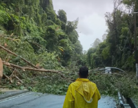
She said some residents and business owners have been speculating about the slope issues around the area, “but they are not aware of the mitigation steps that need to be taken.”

However, she said she is aware that the proposed sharing of information could also bring undesired repercussions.
“Some residents might panic or become worried about the value of their property,” she said, adding that the matter will be discussed soon with the state administration.
Also in attendance at the town hall were MPAJ president Mohd Fauzi Mohd Yatim, the head of MPAJ’s engineering department Zafrul Fazry Mohd Fauzi, Hulu Langat district officer Ani Ahmad, and Ampang Jaya district police representative Mohamad Fisol Abdullah.
The Ampang MP asserted that she will also present several proposals to Parliament regarding the slope issues.
“Among the recommendations is for more aggressive slope watch efforts and taking preventive measures before the undesirable happens.
“The platform management on the slope issues also needs to be streamlined so all the agencies involved can (work) together to solve them – not just when there is a landslide – but discuss collectively and put things in perspective, get the right budget allocation to solve the slope issue in the long run,” she explained.
During the presentation at the town hall, MPAJ engineering head Zafrul suggested that the UTM risk-mapping study on the slopes around the Bukit Antarabangsa constituency – that include Taman Sering Ukay, Ukay Heights, and Dataran Ukay – be shared with stakeholders.
I think the residents have the right to know and perhaps we should be transparent about some information,” he said.
.jpg)
While the noble intention to disclose the study is understandable, a long-time observer told The Vibes that the information may be interpreted differently by certain quarters if revealed.
It may cause certain quarters to be unhappy or be afraid of their home surroundings every time it rains,” she said.
The observer recalled a similar disclosure of a hazard map snapshot in Hong Kong some time ago which had caused a legal wrangle.
“The authorities and a team of researchers had to face legal action from property developers when their development areas were labelled as highly hazardous,” she said. – The Vibes, January 21, 2023